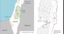
Geography, politics stand in way of independent Palestinian state
London, Sep 26 (The Conversation) There has been a recent rush of countries to formally recognise the state of Palestine. Affirming Palestinian sovereignty marks a historic diplomatic milestone, yet the exact layout of its territory, a central requirement under international law, remains fiercely contested from every hilltop in the West Bank to the ruins of Gaza. To grasp what this moment means, we need to trace how borders have evolved or dissolved over Palestines tumultuous political history. The 1947 UN partition plan had envisioned two semi-contiguous territories for Jewish and Arab states, with Jerusalem as an international city.