Ditwah weakens into well-marked low pressure area, brings widespread rains in Chennai
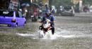
CHENNAI: The depression which is left of cyclonic storm Ditwahweakened into a well-marked low pressure area over the North Tamil Nadu- Puducherry coasts early on Wednesday morning. After another night of moderate to heavy spells of rain, the city's cumulative rainfall over the last 24 hours averaged at 6.17 cms as on Wednesday morning. As the system moves further inland, parts of the state may continue to receive good spells although the Regional Meteorological Centre has not issued district-specificwarnings for very heavy rainfall as of Wednesday morning. Chennai andneighbouring districts may continue to receive rain until Wednesday night. After bringing heavy rains to Chennai by staying put, remnant Ditwah changes direction Parts of North Chennai received yet another heavy spell on Tuesday night with Ennore recording the highest rainfall of 13.5 cms followed by Wimco Nagar where 11.8 cms of rain was recorded. The Southern parts of the city were, however, not too far behind.According to Chennai corporation data, Medavakkam also received heavy spells of rain, recording 10.5 cms while Pallikaranai recorded around 9 cms. Parts of Ramanathapuram also received rainfall in the period from 8:30 am on Tuesday to 5:30 am on Wednesday with the observatory in Tondi (Ramanathapuram) recording 9.5 cms of rain. The system is expected to further weaken into a low-pressure area in the next 24 hours.

 23 C
23 C