Chennai plans commodity-based freight model as incomplete land-use maps hinder traditional approach
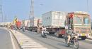
CHENNAI: The Chennai Unified Metropolitan Transport Authority (CUMTA) and consultancy Ernst & Young (EY) are preparing a freight movement model for Chennai that shifts from land-use forecasts in favour of a commodity-based approach. Instead of relying on incomplete maps of industrial and commercial zones, the model estimates demand from projected cargo volumes identifying what kinds of goods will move, and in what quantities, to give a more reliable picture of the citys logistics needs, according to sources. Officials had initially sought to link freight demand to land use by mapping factories, warehouses and commercial hubs. But when they turned to the Chennai Metropolitan Development Authority (CMDA) for data, they found that detailed land-use maps were unavailable for much of the region. The CMDA is still preparing the citys third master plan, which covers only 1,189 sq km of the older metropolitan boundary. In the expanded areas, only broad growth zones have been identified, which would not be enough to support freight modelling. A senior CUMTA official told TNIE that the expanded metropolitan area falls under the jurisdiction of the Directorate of Town and Country Planning (DTCP). Since the CMDAs third master plan covers less than one-fifth of the total area, we opted for a commodity-based approach, as identifying land use in the expanded zones will take time. This approach is around 75-80 per cent accurate, the official said. Land use and transport are each the function of the other, said KP Subramanian, former professor of urban engineering at Anna University. Wider roads and the consequent commercial and industrial uses attract traffic. Land use and transport integration is a fundamental principle of any city development plan. It is surprising that CUMTA has sponsored a study to forecast freight volumes without factoring in proposed land use. Ideally, the freight forecast should be integrated into the CMDAs third master plan and the master plan itself should cover the expanded 5,904 sq km area. He added, The freight forecast will be unreliable without clarity on the proposed transport network and industrial locations. The shorter the horizon period, the more accurate the projections - which should be updated once every five years.

 29 C
29 C