A tropical storm may be developing in the Gulf. Models don't rule out U.S. impacts.
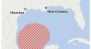
The Atlantic Ocean hasnt seen a hurricane yet this year in a season that remains among the quietest on record, driven by a strong El Nio pattern thats getting even stronger. But the Gulf of Mexico may be about to cook up a storm, and theres at least some chance of U.S. impacts. The National Hurricane Center is monitoring a nascent disturbance in the Bay of Campeche, or southwestern Gulf of Mexico, west of the Yucatn Peninsula. The agency estimates development odds at 70 percent, with weather models including Googles DeepMind indicating increasing chances. Infrared satellite imagery Sunday night revealed a flare-up of thunderstorm activity. The tropical wave was still disorganized, though, and lacked any cohesive spin or a center. For now, its merely a disturbance. Get Climate Coach newsletter News and guidance on climate, science and technology. Sign up for free However, its possible that spin will consolidate in the coming days, becoming a more organized system. Some of that spin is caused by northerly winds being funneled down Mexicos Sierra Madre Occidental mountain range; there, they meet southeasterly winds from the Caribbean. Like an atmospheric waterwheel plopped in between opposing currents, this makes the fluid spin. Most Read From The Washington Post Trumps opponents are planning efforts to reverse his changes to presidency An election chief lost. Then he padlocked the ballots and called the FBI. SNL takes aim at Trumps Republican allies with cold open The drugstore staple dermatologists swear by for dry, cracked skin Why you should think about getting your flu shot right now The American GFS model simulates a tropical depression forming by Wednesday, though the European model depicts more gradual development. Still, it bears watching, given water temperatures in the Bay of Campeche are between 85 and 87 degrees. If the American model prevails and hypothetical development ensues faster, the system could be tugged northeastward. It would hitch a ride with an approaching upper-air disturbance, probably being slowly pulled northeast toward the U.S. Gulf Coast. Alternatively, broad clockwise flow in the upper atmosphere may push it west into coastal Tamaulipas or Veracruz, Mexico. Theres still a chance the system never comes together and remains a messy clump of showers. Even if the disturbance does become a hurricane and head toward the United States, it probably wouldnt be able to strengthen beyond a high-end Category 1 or borderline Category 2. Why? The subtropical jet stream is slicing across the southern U.S., introducing disruptive wind shear, or changing winds with height. That means any system would be knocked off-kilter and left a bit disheveled, weakening before it could make a U.S. Gulf landfall. So for now, Gulf residents should simply keep half an eye on the forecast. Theres nothing to worry about yet. Meteorologists will have a clearer picture by Wednesday. This article originally appeared on Washington Post at https://www.washingtonpost.com/weather/2026/10/05/tropical-storm-could-form-gulf-mexico-coming-days/